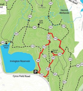
The trails in the Irvington Woods provide for everything from leisurely strolls to strenuous bicycle rides. To help you plan a route and gauge distances, here are a few hike suggestions that begin at the South Parking Lot on Cyrus Field Road, and a few that begin at the O’Hara Nature Center.
Beginning at the South Parking Lot on Cyrus Field Road
Short Route to Sunset Rock – .8 mi
This loop leads to Sunset Rock, which offers beautiful panaromic views of the Hudson River to the West and the Saw Mill River Valley to the East. At the northern point of this loop, you can add detours to visit Split Rock and Hermit Wetlands. In total it climbs about 120 feet with no steep sections.
Long Route to Macy Monument and Sunset Rock – 1.25mi
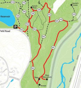
This loop leads to Sunset Rock and Macy Monument, which is tucked below a long section of steps. On the way, you will see remnants of old estates that occupied these woods, including a stone terrace, steps and a bench. If you have a few extra minutes, follow the trail’s extension to Hermit’s Grave, the only marked grave in Irvington. In total, it climbs about 200 feet and has modestly deep sections.
Full Perimeter Route – 3 mi
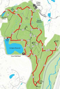
This route provides the longest possible route as it visits, or passes near, all of the historic or natural points of interest. It passes by Hermit’s Grave as well as Hermit’s Wetlands where you can search out some of the many species of birds that live and feed there. The route also passes by Macy Monument, a plaque honoring V.E. Macy, which is beautifully encased in a large granite formation. As it passes by the Irvington Reservoir, you can visit the glacially formed Jenkin’s Rock. Along this route you can also take quick detours to visit Split Rock and Sunset Rock. In total, it climbs about 200 feet and has modestly deep sections.
From the trailhead behind the O’Hara Nature Center:
Short Route to Split Rock – 1.25 miles
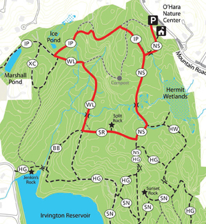 This loop leads to Split Rock, a striking glacial erratic that was carried for miles by glacial ice. It passes by Hermit Wetlands, where you can search out some of the many species of birds that live and feed there. It also passes by the Ice Pond, which was built and used to harvest ice for the icehouses on the nearby estates. There are no major climbs and no steep sections.
Long Route to the Irvington Reservoir – 1.75 miles
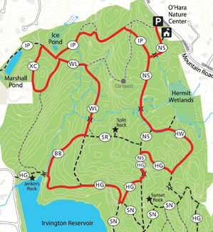 This loop leads to the Irvington Reservoir, where you can visit the glacially formed Jenkin’s Rock. It passes by Hermit Wetlands and the Ice Pond, which was built and used to harvest ice for the icehouses on the nearby estates. You can include a quick detour to visit Split Rock, just a short distance off the loop. In total, there is a modest climb and no steep sections.
Full perimeter Route – 3 miles
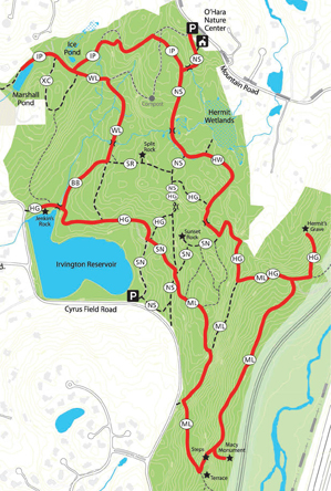 This route provides the longest loop possible as it visits, or passes near, all of the historical and natural points of interest. It passes by Hermit Wetlands as well as Hermit’s Grave, which is the only marked grave in Irvington. This route also passes by Macy Monument, a plaque honoring V.E. Macy, which is beautifully encased in a large granite formation. As it passes by the Irvington Reservoir, you can visit the glacially formed Jenkin’s Rock. Along this route, you can also include quick detours to visit Split Rock and Sunset Rock. In total, it climbs about 200 feet and has modestly steep sections.

